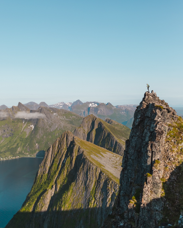
The triple threat in hiking, more commonly known as the triple crown in hiking is some of the longest thru-hike trekking trails in the United States. They include the Appalachian Trail(AT), the Continental Divide Trail(CDT), and the Pacific Crest Trail(PCT).
The triple crown is a total of around 8000 miles and needs a lot of endurance and determination to complete it. The trail passes through 22 states and goes up to one million feet of cumulative elevation gain. As per ALDHA west, there are about 334 Triple Crowners to date.
There are a few impressive feats from some amazing individuals. It was Mr. Eric Rayback who completed the triple crown first and Heather Anderson is the second female who completed the Triple crown ‘twice’. She is planning to do it for the 3rd time within a year. While most of us like to take a few years to break even in between two routes!
What makes these trails rather famous? Let’s take a look!

Table of Contents
Triple Threat In Hiking
Appalachian Trail (AT)
The trail is 2,190 miles long and ranges from Mount Katahdin in Maine up to Springer Mountain in Georgia. The trail travels across 14 states and requires around 5-7 months to complete. The point with the topmost elevation is the Clingmans Dome in Smoky Mountains National Park which peaks at around 6,643 feet. The elevation alters about 917,760 feet with an average of 420 feet/miles.
The trail hosts around 3 million hikers in a single calendar year which was inaugurated in 1937. Mr. Earl V. Shaffer is the first documented thru-hiker who completed the trail in a single hiking season in 1948.
Geography
The Appalachian Trail is the oldest of the three crown trails and passes through 14 states. The trail includes variance in terrain and is inclusive of the rugged alpine mountains of New England, the rocks of Pennsylvania, and the thick deciduous forests of the south. The trail sections are accessible and it is often termed the Green Tunnel as the dense forest makes it so.
Some sections of the trail are too steep and with weird-looking paths. The trail itself is enclosed within greenery with very less exposure to scenic peaks which is completely altered to other major routes.
The weather on the Appalachian Trail is rather predictable. The trail has variances like light to moderate rain, and moderate temperature ranges and is also quite humid. The cold weather conditions are rather short-lived and most of the hikers experience an entire change of seasonal wardrobe that they carry around!
Provision and Wilderness
The Appalachian Trail is not as remote as the PCT or the CDT as it crosses tons of public trails and small towns that make hiking around a lot easier and hitchhiking possible too! The trail even has around 250 on-foot shacks/shelters to help the hikers find shade. So the track is rather safe for travel and you might not need to carry quite a heap alongside your rucksack with essentials.
The wilderness has both beasts and small creatures that beautify the visuals. The fauna that you will definitely notice include ticks, mice, deer, and bears (well that rhymes!). The Bears are known to be very friendly and even might wish for some food with you!
Wildlife is common, especially bears, deer, and of course, mice in the shelters that try to steal your food. Bears are a concern in the Smoky Mountains with shelters sometimes closed due to a nuisance from those bears. Moving to the North could have you to encounter a swarm of mosquitoes and biting flies!
The Appalachian trail hosts amazing social interactions as compared to other areas. The route is provided with share shelters, trail towns, and amazing social experiences with a large inflow of thru-hikers. Even if you hike alone or there are smaller groups that hike, the groups unite for a certain time known as trail families.

Pacific Crest Trail
The trail is 2,650 miles long and ranges from Campo, CA on the Mexican border up to the US border at Manning Park in British Columbia The trail travels across three states and requires around 4-6 months to complete. The point with the topmost elevation is the Forester Pass in Smoky Mountains National Park which peaks at around 13,153 feet. The elevation alters about 824,370 feet with an average of 309 feet/miles.
The trail hosts Millions of hikers in a single calendar year, yet completed by only a handful, which was inaugurated in 1932 and completed in 1993. Mr.Eric Ryback is the first documented thru-hiker who completed the trail in a single hiking season on October 16, 1970.
Geography
The Pacific Crest Trail lengthens from Mexico to Canada with Washington. The Trail is hosted across nine ecoregions of North America and many protected areas. The trail is not too steep yet starts off a desert off to the trail across the scenic Sierra Nevada, with alternate ascent and descent pathways. The altitude might give off altitude sickness. The trail is mostly upon scenic areas with views across the mountains and with very few green forest tunnel trails.
The place however is not as maintained as the AT and demands supplies to keep your bearing. You would need GPS devices, maps with compass maps, and also a physical compass to track your location. The trail would demand loads of supplies and would take up to 4-5 months.
The start of trails on the deserts is quite hot while ice capes and snowfall seem prevalent on the trails below. The PCT requires equipment like microspikes, ice axes, and tons of supplies to keep you warm. The summer might make you witness forest fire with smoke all across the pathway, which you have to be extremely careful about.

Provision and Wilderness
The path crosses across desert, mountains, and forest which causes the PCT to host a wide variety of wildlife. The desert hosts scorpions, lizards, and rattlesnakes in the deserts and biting bugs and mosquitos are found in the Sierras. The Northern part of the trails have deers, Marmot, elk mule deer, mountain goats, and bears.
The PCT itself is a harder trail. The trail would require you to fill up water in the caches as water is scarce. While the Sierra areas host a nice amount of water resources. The distance of water refilling is of actual concern. Hikers must be loaded with a water supply and food supply.
The PCT is rather uncivilized as compared to the AT. The PCT does not feature shacks like in AT but has gathering points in most water sources that serve as reliable camping spots. The path is mostly sparsely crowded yet you will find a company for sure! The trails are supplied with trail magic where trail angels would aid you if you are low on supplies!
There are groups of dedicated trail angels, known to be in specific locations providing trail magic but random support is rare. The trail is provided with trail towns and settlements too but they are a bit off-route and not much frequent as on the Appalachian Trail.

Continental Divide Trail
The trail is 3,100 miles long and ranges from Crazy Cook Monument up to Waterton Lake, Glacier National Park, Montana at the U.S.–Canada border. The trail travels across five states and requires around 4-6 months to complete. The point with the topmost elevation is Grays Peak, Colorado, which peaks at approximately 14,278 feet. The elevation alters about 917,470 feet with an average of 303 feet/miles.
The trail hosts around 300 hikers in a single calendar year which was inaugurated since National Scenic Trail in 1978. Mr.Eric Ryback is the first documented thru-hiker of this trail too.
Geography
The Continental Divide Trail moves across 5 states, starting off from the New Mexico Desert and the Rocky mountains in Colorado. The trail crosses the Great Basin in Wyoming and ends in Montana and Idaho. The pathway crosses protected areas like the Yellowstone, Glacier, and Rocky Mountain National Parks.
The trail itself is not completed yet and hosts paved roads and dirt trails along the path. However, the path hosts trails for horses and mountain bikes. The trail is unfinished and is completed only up to 76%. The track itself might be confusing, the travelers are preadvised to take a GPS device alongside a compass and maps.
The weather on the CDT ranges from super hot deserts to cold icy peaks. You might experience lightning, high winds, cold, and much more. The hike would require a complete supplement of clothing and foodstuffs.
Provision and Wilderness
New Mexico is provided with open pastures for cows and the deserts host rattlesnakes, lizards, and likewise. The trail also hosts grizzly bears, black bears, wolves, wolverines, mountain goats, and so on!
The CDT is a rather tough trail with a few resupply points that require you to walk quite a distance. The trail has much fewer trail towns and you might have to walk away from the actual path up to quite a distance to reload yourself with supplies.
The weather pattern might cause seasonal differences that might cause alternations with the filling/ refilling of the water sprouts. The trail also has water reservoirs like cattle ponds or below windmills.
Because of the extreme trail conditions, the PCT itself is quite tough to hike across. You would require loads of supplements to hike across the trail and the pathway is quite tough to cover too! The path ain’t something like sipping a cup of tea. You might even crave to see travelers like yourself across the path!
Conclusion
The AT, PCT, and CDT themselves are known as triple-crown trails, also known as the triple threats. The Appalachian trail itself is made of a fine paved trail which is provided with trail magic and has all the privileges that the other tracks do not have.
The PCT itself is a bit harder while the CDT itself is the hardest one with quite some issues in the track, let’s say that the track itself is not finished and also lacks a sophisticated amount of trail towns for resupplies.